Is Your Household Storm-Ready?
Five quick questions. Find out before 4 p.m. hits.
Do you have severe weather alerts turned on for your phone?
- Yes, wireless emergency alerts are on — Good. Today's storm window runs from 6 p.m. to midnight — your alerts should fire well before storms reach your neighborhood.
- I get some alerts but I'm not sure which ones — Check your phone settings now. With storms expected to drop south through the Tri-State starting around 6 p.m., you want the earliest possible notice.
- No alerts set up — Today is the day to fix that. Damaging wind gusts are the primary concern with this storm setup — you need advance warning to get inside.
Does everyone in your home know where to go if a tornado warning is issued?
- Yes, we have a designated interior space — Perfect. While damaging wind gusts are the main concern today, an isolated tornado cannot be ruled out — having a plan in place matters.
- We'd figure it out in the moment — A tornado warning leaves little time to improvise. The storm line is expected to move through quickly between 6 p.m. and midnight — talk it through with your household before then.
- No plan in place — Pick your lowest-level, most interior room before this evening. Isolated tornadoes are on the table for tonight's First Warning Weather Alert Day.
Have you secured or brought in any outdoor furniture, decorations, or loose items?
- Everything is secured or inside — Smart move. Damaging wind gusts are listed as the primary severe weather risk for tonight's storm event across the Tri-State.
- Some things, but not all — Focus on the heaviest and most airborne items before 4 p.m. — that's when storm chances begin to increase today.
- Nothing moved yet — You still have time. Storms aren't expected to arrive until after 4 to 5 p.m. Use the next few hours to clear your yard — damaging wind gusts are the top threat tonight.
Do you know if your regular route home or neighborhood is prone to flash flooding?
- Yes, and I have an alternate route — Good preparation. Tonight's storm setup includes the risk of 'back building' — where new rounds of storms develop behind the first line — increasing heavy rainfall and flash flooding potential.
- I think my area can flood but I haven't checked — Check before you leave for home today. Back-building storms could produce repeated rounds of heavy rain between 6 p.m. and midnight across the Tri-State.
- I've never thought about it — Flash flooding is explicitly listed as one of tonight's risks. The 'back building' pattern means new storm rounds can pile additional rain onto already-saturated ground.
Are you prepared if the power goes out tonight?
- Yes — flashlights, battery backup, plan in place — Excellent. Duke Energy's outage map is available for tracking if lines go down tonight during the storm window.
- We have some candles and that's about it — Candles are a start, but find a flashlight too. Damaging wind gusts — tonight's primary threat — are the most common cause of power outages during storm events.
- Not prepared at all — Charge your devices now while you have power. Damaging wind gusts are the leading severe weather threat tonight — outages are a real possibility for Tri-State residents.
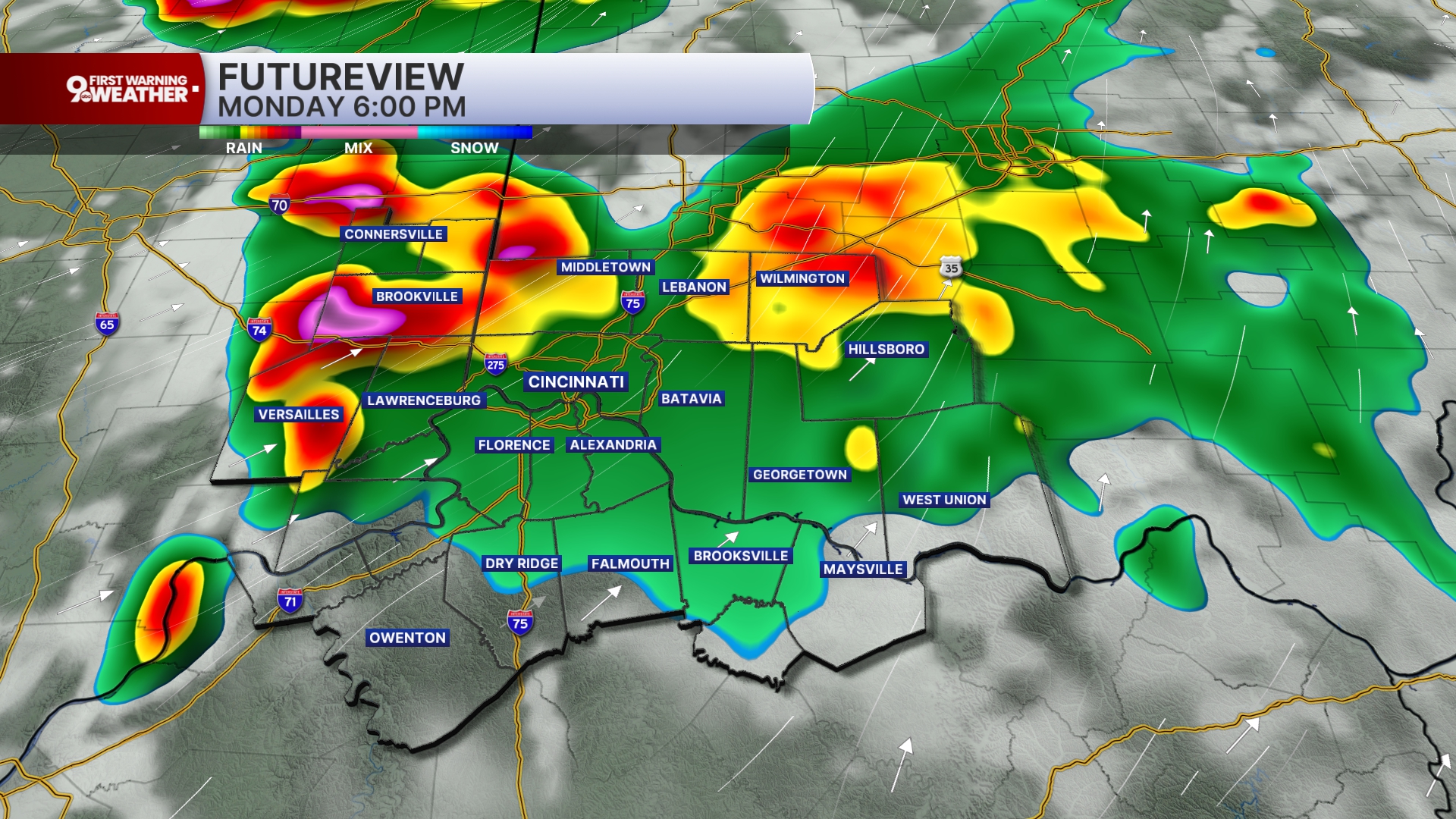
The storm setup today carries a specific risk that forecasters call 'back building' — and it's the reason flash flooding is a serious concern, not just an afterthought. With back building, an initial line of storms moves through the area, but then new rounds of storm activity develop on the trailing edge. The result: multiple waves of heavy rain hitting the same ground in the same night.
That repeated soaking is what turns a manageable rain event into a flash flooding threat. Tri-State residents near low-lying areas or historically flood-prone roads should have an alternate route identified before 6 p.m.
Today's Storm Timeline
- Now – 4 PM — Partly cloudy and muggy
- 4–5 PM — Storm chances begin to increase
- 6 PM — Storms start dropping south through the Tri-State
- 6 PM – Midnight — Primary storm window — damaging wind gusts, hail, isolated tornado, flash flooding possible
- Overnight — Spotty storms continue, then fade before sunrise
- Tuesday — North winds pull drier, milder air from Canada — high of 85°
Your quiz score benchmarks against what today's storms actually demand. Even a grade of C reflects real gaps that could matter between 6 p.m. and midnight — the hours when this storm line is expected to move through the region. A grade of A doesn't mean nothing happens to you; it means you've done what you can to be ready when it does.
The good news: north winds will shift through on Tuesday, pulling cooler, less humid air down from Canada. Highs drop to 85°, humidity retreats, and a drier pattern takes hold for the rest of the week. Tonight is the storm to get through — and then the Tri-State gets a break.
Cincinnati's Weather: Monday Through Tuesday Night
| Timeframe | Conditions | Temperature | |
|---|---|---|---|
| Monday Morning Rush | Partly cloudy, patchy fog, muggy | Storms holding off | Low: 71°F |
| Monday Afternoon | Partly cloudy, very humid | Feels like mid-90s | High: 88°F |
| Monday Night | Storms continue, overcast | Muggy, low visibility possible | Low: 72°F |
| Tuesday Day | Partly cloudy, slight rain chance | Drier, north winds from Canada | High: 85°F |
| Tuesday Night | Partly cloudy | Milder, noticeably lower humidity | Low: 66°F |
What's True About Today's Storm Threat
Storms will arrive in Cincinnati all day — it's already dangerous outside.
Verdict: false
Storm chances are expected to hold off until after 4 to 5 p.m. The morning and early afternoon are partly cloudy and muggy, but storm-free. You have a preparation window — use it.
Tornadoes are the main threat with today's storm setup.
Verdict: mostly false
Damaging wind gusts are listed as the primary concern. An isolated tornado cannot be ruled out, but it is not the leading risk. Large hail and flash flooding are also on the table.
Back building storms can mean multiple rounds of heavy rain.
Verdict: true
Forecasters specifically flagged back building as a concern for tonight. It occurs when new storm rounds develop behind the initial line, increasing the risk for heavy rainfall and flash flooding.
The rough weather continues all week.
Verdict: false
Tuesday brings a drier pattern with north winds pulling in less humid air from Canada. The rest of the week shapes up significantly calmer, with humidity staying in check as north winds continue.
Before 4 PM: Your Storm Prep Checklist
- Charge every device now — Damaging wind gusts are tonight's primary threat — power outages are a real possibility. Charge phones, tablets, and backup batteries while the grid is stable.
- Secure your outdoor space — Bring in or tie down furniture, umbrellas, decorations, and anything that could become a projectile in high winds. Do this before 4 p.m.
- Know your lowest, most interior room — While an isolated tornado is not the primary risk, it cannot be ruled out. Identify your safe spot before the storm window opens at 4 to 5 p.m.
- Check your route home for flood-prone areas — Back-building storms can drop repeated rounds of heavy rain. Know an alternate route if your normal path is near low-lying or historically flood-prone roads.
- Turn on wireless emergency alerts — Storms are expected to drop south through the Tri-State from 6 p.m. to midnight. You need the earliest possible warning to get inside before a storm reaches your area.
- Track the radar after 4 PM — Use WCPO's interactive radar to watch storm movement toward your specific address as the window opens. The line is expected to push from north to south.
Cincinnati Storm Resources
- Track Storms to Your Doorstep: WCPO's interactive radar lets you watch storm movement in real time as conditions develop after 4 p.m.
- Duke Energy Power Outages: Check the latest outage map if wind gusts take down lines in your neighborhood tonight.
- Metro Bus Detours: Storm-related route changes will be posted as conditions develop. Call the Metro detour hotline for live updates.
- CVG Flight Status: Check flight cancellations and delays at CVG and other U.S. airports if you're traveling tonight.