Your Outdoor Window
Monday starts deceptively pleasant — dry skies, partly cloudy, temperatures in the low 70s as you head out the door. But don't be fooled. Clouds thicken through the morning, humidity climbs, and by noon Cincinnati hits 82 degrees under mostly cloudy skies.
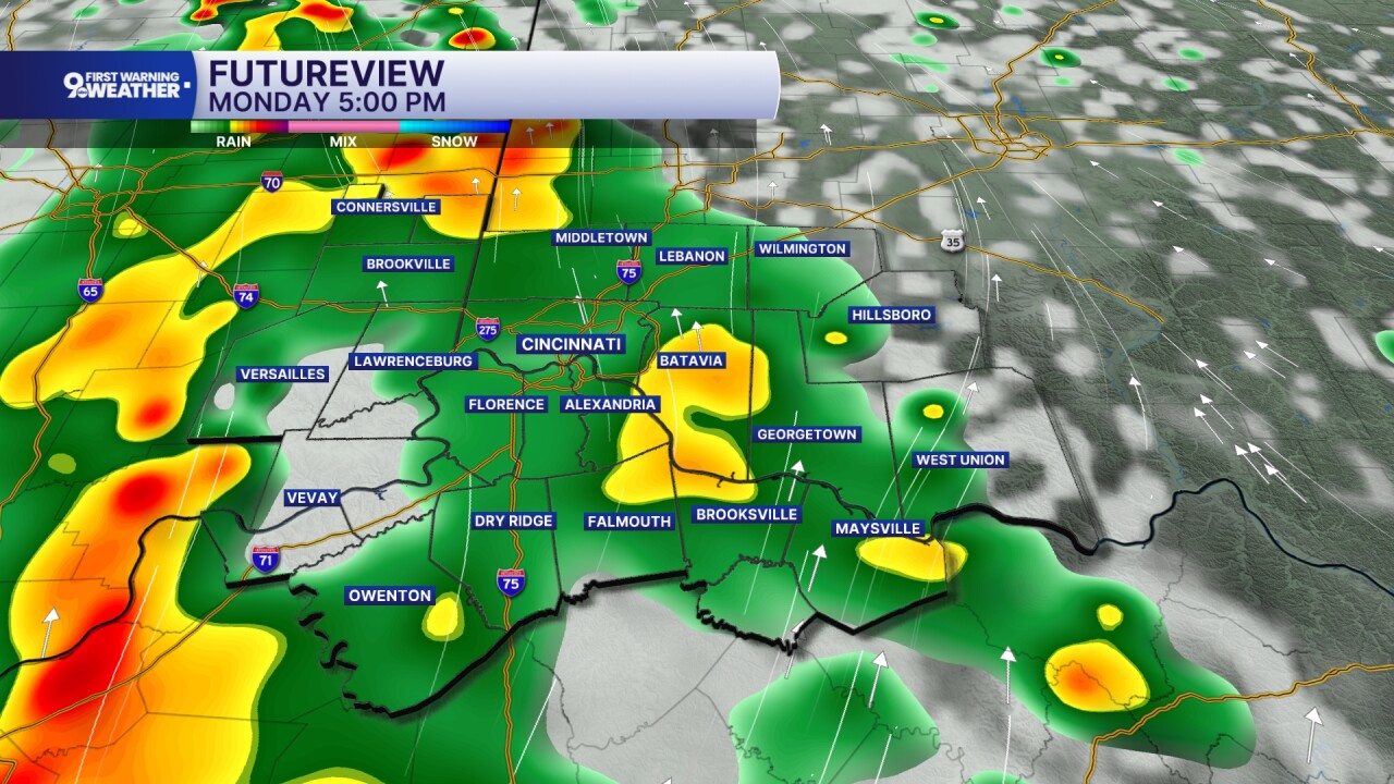
The storm timing is the key thing to know: showers push into southwestern Hamilton County and the Northern Kentucky communities between 2 and 3 PM Monday, then track northeast through the rest of the afternoon. If you're in Anderson Township, Hyde Park, or east-side neighborhoods, you may get an extra hour of dry time. If you're in Price Hill, Western Hills, or just across the river in Covington or Florence, the rain arrives first.
The Storm Timeline: Monday Through Wednesday
- Mon 6 AM — Dry start — low 70s, partly cloudy, muggy
- Mon Noon — Clouds thicken, 82° — still dry
- Mon 2–3 PM — Storms enter from the southwest — Price Hill, Western Hills, Covington first
- Mon Evening — Showers move northeast through the area — high of 83°, feels like 89°
- Mon Night — Overnight dries out — warm and muggy, low of 70°
- Tue 9 AM–3 PM — Isolated showers mainly east of I-71 — not widespread
- Tue Afternoon — Partly cloudy break — high 83°, feels like upper 80s
- Tue Midnight+ — Larger storm cluster arrives — soaking rain and thunder
- Wed Morning — Storms continue through the morning commute — plan ahead
- Wed Noon — Rain wraps up — dry rest of day, highs in the mid 80s
Tuesday brings a break in intensity — isolated showers, mainly east of I-71, running from 9 AM to 3 PM. That means communities like Milford, Batavia, and areas toward Clermont County face the greatest Tuesday rain chance. Most of Hamilton County and Northern Kentucky should see less activity.
But the real story is Tuesday night into Wednesday morning. A larger cluster of storms organizes to our west and drives into the Cincinnati area after midnight, bringing heavy rainfall and rumbles of thunder. Overnight lows hold at 70 degrees — there's no relief from the humidity. The Wednesday morning commute will be wet. Rain clears before noon, and the afternoon looks dry with mid-80s temperatures.
Are You Storm-Ready This Week?
Five quick questions — find out where you stand before the storms hit.
Do you have weather alerts set up on your phone?
- Yes — WCPO app or Wireless Emergency Alerts — You're set. WCPO's 9 First Warning app sends push alerts before storms hit your specific area.
- I rely on TV or radio — Good backup. Add mobile alerts so you're covered even when the TV is off — especially for the late-Tuesday overnight system.
- No alerts set up — This week's active pattern makes now the time. Download the WCPO 9 app and enable push notifications for your neighborhood.
Do you have a plan for the Wednesday morning commute?
- Yes — I'll leave early or work from home — Smart call. Heavy rain from the overnight system is expected to continue through the morning rush. Extra travel time will help.
- I'll check conditions that morning — Check the WCPO radar before you leave — if streets in your area are flooding, give it 30 extra minutes. Rain clears before noon.
- I haven't thought about it — Block a reminder now: Wednesday morning commute will be affected by overnight storms. Rain clears by noon, so later departures are cleaner.
Do you have outdoor plans Monday afternoon or Tuesday night?
- No outdoor plans those windows — You're in good shape. The afternoon and morning hours look mostly clear on both days.
- Monday afternoon plans — Storms arrive from the southwest between 2–3 PM Monday. Wrap up outdoor activities before 2 PM or push to evening — it should dry out overnight.
- Tuesday evening or overnight plans — The larger storm cluster arrives after midnight Tuesday. If you have late plans, watch the radar — storms may arrive earlier than expected.
Does your home or workplace have a safe interior room away from windows?
- Yes — interior room, first floor or below — Good. While severe weather isn't forecast this week, knowing your shelter spot is always smart during any storm season.
- I'm in an apartment — unsure — Look for an interior hallway or bathroom away from exterior walls. Avoid windows even in non-severe storms.
- Not sure where I'd go — Identify your shelter spot now: an interior room on the lowest floor, away from windows. This week's storms aren't severe, but it's always worth knowing.
How often do you check the forecast during an active weather week like this?
- Daily — I stay on top of it — That's exactly what WCPO's Jennifer Ketchmark recommends for this stretch: check in daily as timing details shift.
- Only when I see dark clouds — Reactive checking can leave you caught off-guard, especially with the overnight Tuesday system. Set a daily weather check habit this week.
- I'll just wing it — This week especially — with 5 storm windows in 3 days — daily forecast checks will save you from getting caught out. Bookmark wcpo.com/weather.
Day-by-Day: What to Expect
| Monday | Tuesday | Wednesday | |
|---|---|---|---|
| Morning Conditions | Dry, partly cloudy | Partly cloudy | Heavy rain continues |
| High Temp | 83°F | 83°F | Mid-80s |
| Feels Like | ~89°F | Upper 80s | Humid |
| Storm Risk | Moderate (2–3 PM) | Low (east of I-71) | High (AM rush) |
| Overnight Low | 70°F (muggy) | 70°F (muggy) | Clearing by noon |
| Commute Impact | Watch afternoon | Minimal | Plan for delays |
This Morning vs. Wednesday Morning
Monday Morning
- 73° Temperature Comfortable start
- Dry and partly cloudy
- Muggy but manageable
- No rain gear needed yet
Wednesday Morning
- 70°+ Temperature Humid and wet
- Heavy rain through the commute
- Overnight storms still clearing
- Rain wraps up before noon
The through-line for all three days is humidity. Overnight lows aren't dropping below 70 degrees — that's the kind of oppressive, sticky heat that makes a cloudy, rainy day feel even more draining. Heat index values on Monday reach 89 degrees despite an air temperature of 83.
The good news: severe weather is not in the forecast for this stretch. These are rain events — some with thunder — not tornado or damaging wind threats. But 'not severe' doesn't mean 'not disruptive.' Flash flooding is possible with the heavy overnight rain Tuesday into Wednesday, and the morning commute Wednesday will be slower across the region.
Your 3-Day Storm Action Plan
- Monday: Protect the Afternoon — Move outdoor activities before 2 PM or after 8 PM. Storms enter from Price Hill and Western Hills first, tracking northeast. Keep the umbrella in the car all day.
- Tuesday: Watch East of I-71 — Isolated showers from 9 AM–3 PM, mainly east of the interstate. Milford, Batavia, and Clermont County face the most Tuesday activity. Most of Hamilton County sees less.
- Tuesday Night: Set the Alarm — The largest system arrives after midnight. If you commute Wednesday morning, check the WCPO radar before you leave. Consider leaving early or planning for delays.
- Wednesday Noon: It Clears — Rain wraps up before noon Wednesday. If you can push outdoor plans to Wednesday afternoon, you'll get a dry window with mid-80s temperatures.
- All Week: Check Daily — This is an active pattern. Timing details will shift. WCPO's 9 First Warning Weather team updates the forecast daily — bookmark wcpo.com/weather or enable app alerts.
Stay Ahead of the Storm
- Sign Up for Severe Weather Alerts: Get WCPO's 9 First Warning Weather alerts directly to your inbox before storms hit.
- Interactive Radar: Track to Your Doorstep: WCPO's live radar lets you zoom into your exact neighborhood and track rain in real time.
- Duke Energy Power Outage Map: If the overnight storms knock out power, track outages and restoration status in your area.
- Metro Bus Detours & Updates: Wednesday morning flooding could affect bus routes. Call the Metro hotline at 513-632-7538 for real-time detour info.
Sources & References
- Primary source: wcpo.com — https://www.wcpo.com/jennifer-ketchmark
- WCPO 9 First Warning Weather — Storm timing, temperature, and precipitation forecasts for the Cincinnati region
- National Weather Service — Wilmington, OH — Severe weather watch/warning status and regional forecast data for Greater Cincinnati
- Duke Energy Ohio/Kentucky — Power outage tracking and restoration status for the Cincinnati region
- Southwest Ohio Regional Transit Authority (SORTA / Metro) — Bus route detour and service disruption updates during weather events