Your Current Fire Risk Level
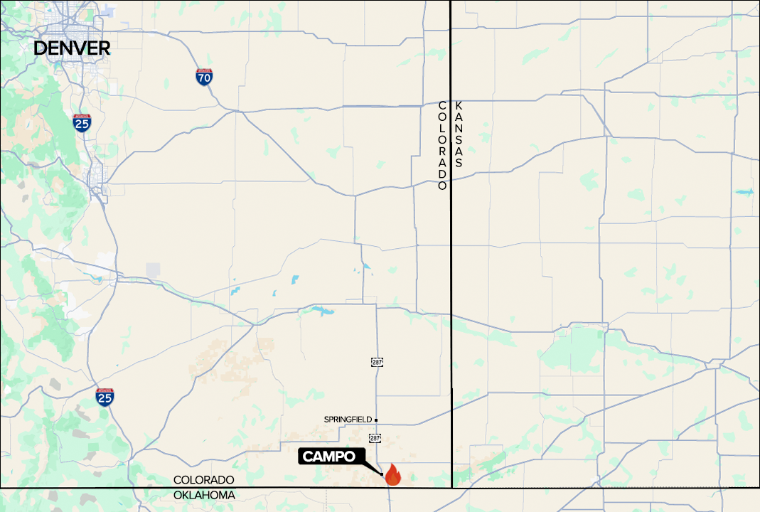
The Sharpe Fire began in Oklahoma before jumping the state line into Colorado's Baca County on Sunday — a reminder that in southeastern Colorado's flat, wind-swept plains, a wildfire has no respect for borders or property lines.
Campo, a small agricultural community in the far southeast corner of the state, found itself in the fire's path. By Monday morning, firefighters had successfully held the fire line through the night, with a limited crew remaining on scene to manage flare-ups along the full perimeter.
Sharpe Fire: How It Unfolded
- Sunday — Fire crosses into Colorado from Oklahoma near Campo
- Sunday — Evacuation orders issued for Baca County residents
- Sunday Night — Fire line around Campo holds overnight; limited crews manage flare-ups
- Sunday Late — All Baca County evacuation orders lifted
- Monday — 18,000 Colorado acres confirmed burned; 28,200 total with Oklahoma acreage
- Mon–Tue — Red flag warning active: 20–35 mph winds, gusts to 50 mph, humidity as low as 6%
- Tuesday 8 PM — Red flag warning set to expire — conditions reassessed
Despite the scale of the fire, officials confirmed Monday that no residences have been lost. That's a remarkable outcome given the fire's size and speed — a testament to the work of crews on the ground and the relatively sparse population of Baca County's agricultural landscape.
But officials are not declaring victory. A red flag warning from the National Weather Service in Pueblo covers southeastern Colorado through 8 p.m. Tuesday, with forecast winds of 20–35 mph and gusts up to 50 mph. Relative humidity could drop as low as 6% — conditions that make any ember a potential ignition source.
Are You Ready for a Wildfire Emergency?
Four quick questions to assess your preparedness — especially important for rural Colorado residents.
Are you signed up for your county's emergency alert system?
- Yes, I receive alerts — Great. Make sure your contact info is current and alerts are set for your specific area.
- No, I haven't signed up yet — Baca County is urging ALL residents to sign up now at the county emergency management page. Alerts can be the only warning you get.
- I'm not sure — Check with your county emergency management office. In rural Colorado, official alerts are often the fastest — and only — warning system available.
Do you have a go-bag packed and ready for a quick evacuation?
- Yes, packed and accessible — Ideal. Keep it near an exit and review contents seasonally. Include medications, documents, phone chargers, and water.
- Somewhat — basics are around but not packed — When a fire moves at 50 mph wind speed, there's no time to gather items. Pre-packing could save your life.
- No go-bag prepared — Start tonight. Colorado Ready recommends a bag with 72 hours of supplies per person. The Red Cross has a free checklist at redcross.org.
Do you know at least two evacuation routes out of your neighborhood or property?
- Yes, I know two or more routes — Excellent. Fire and smoke can block roads unexpectedly — knowing alternate routes is critical in southeast Colorado's rural road network.
- I know one route — Identify a second route now, especially if you're in a rural area where a single road can become impassable quickly.
- I haven't thought about it — Pull up a map today and walk or drive your secondary route so it's familiar before you ever need it under stress.
Have you cleared defensible space around your home (brush, dry vegetation, debris)?
- Yes — cleared at least 30 feet around structures — Good work. Colorado recommends Zone 1 (0–30 ft) be clear and Zone 2 (30–100 ft) have reduced fuel. Review annually before fire season.
- Partially cleared — Focus on the immediate 30 feet first — that's the highest-impact zone for protecting a structure from igniting.
- No, I haven't cleared anything — Even removing debris and dry grass immediately adjacent to your home can significantly improve survival odds. Start with the closest 10 feet.
Residents should be very alert — conditions may change rapidly. Avoid the area as crews continue to fight the blaze.Baca County Office of Emergency Management, Monday statement
Red Flag Warning: What the Numbers Mean
| Current Conditions | Elevated Fire Risk | Extreme Fire Risk | |
|---|---|---|---|
| Wind Speed | 20–35 mph (gusts 50) | 15–25 mph | 30+ mph |
| Relative Humidity | As low as 6% | 15–20% | Under 10% |
| Fire Spread Rate | Extremely Fast | Moderate–Fast | Extremely Fast |
| Ember Travel Distance | Up to 1+ mile | Hundreds of feet | Up to 1+ mile |
| Safe to Return? | No — avoid area | With caution | No |
Overnight: How Conditions Shifted
Sunday Evening
- Active Fire Status Spreading rapidly
- In Effect Evacuation Orders Baca County residents displaced
- Unknown acreage, rapidly growing
- All available crews deployed
Monday Morning
- Contained Line Fire Status Line held overnight
- Lifted Evacuation Orders Residents may return — stay alert
- 28,200 acres total confirmed
- Reduced crew monitoring flare-ups
Baca County officials are urging residents to register for emergency alerts immediately — not after conditions worsen, but now, while there's still time to set up a notification system that could provide critical minutes of warning if the fire reignites.
The county is also asking people to stay out of the area entirely while crews work the fire line. Any additional vehicle traffic creates hazards for firefighters and emergency responders navigating rural roads in smoky, low-visibility conditions.
Fire Weather Threat Factors — Current Conditions
Take Action Now
- Sign Up for Baca County Emergency Alerts: Officials are urging ALL residents in the area to register for real-time emergency notifications. This is your fastest warning system.
- Avoid the Campo / Baca County Area: Crews are actively fighting the fire and need clear roads. Do not enter the area unless you live there and evacuation orders have been lifted.
- Donate to First Responders: Drop off drinks and non-perishable food for firefighters at the Baca County Emergency Operations Center, north of Springfield, CO.
- Colorado Division of Fire Prevention & Control: For wildfire information, resources, and preparedness guidance statewide.
If Conditions Worsen: Your Action Plan
- Monitor alerts continuously — Check Baca County Emergency Management updates and the NWS Pueblo forecast. Wind shifts can change fire direction in minutes.
- Prepare your vehicle to leave immediately — Keep your car fueled and facing out. Load go-bags, medications, irreplaceable documents, and pets before you need to.
- Know your two evacuation routes — Do not assume your normal route will be passable. Smoke, fire, or emergency vehicles may block primary roads.
- Shut windows and close all vents — If fire is approaching, close all windows, doors, and fireplace dampers to reduce smoke intrusion and slow ember ignition inside.
- Leave early — don't wait for the order — If you feel unsafe, go. In rural southeast Colorado, emergency responders may not be able to reach you quickly if you delay.
What's True About the Sharpe Fire
The fire crossed into Colorado from another state.
Verdict: true
The Sharpe Fire originated in Oklahoma before crossing the state line into Baca County, Colorado on Sunday — an unusual interstate fire event driven by extreme wind conditions.
Homes and structures have been lost.
Verdict: false
Officials confirmed Monday that no residences have been lost in the Baca County fire area, despite 28,200 total acres burned.
All evacuation orders have been lifted.
Verdict: true
Baca County lifted all evacuation orders late Sunday. However, officials are urging residents to remain alert as conditions may change rapidly with incoming high winds.
The fire danger is over now that the line held overnight.
Verdict: mostly false
While crews held the fire line, a red flag warning remains in effect through Tuesday 8 PM with wind gusts up to 50 mph and humidity as low as 6% — conditions that can reignite a fire rapidly.
What Is a Red Flag Warning — And Why Does It Matter?
A Red Flag Warning is issued by the National Weather Service when a combination of high temperatures, low humidity, and strong winds creates conditions that can cause a wildfire to start easily, spread rapidly, and become difficult to control.
For the Sharpe Fire area, the NWS Pueblo office has issued a warning through 8 p.m. Tuesday. The forecast calls for winds of 20–35 mph with gusts up to 50 mph — strong enough to drive embers more than a mile ahead of a fire front, potentially igniting new fires well beyond the current burn area.
Relative humidity values as low as 6% are expected. For context, the average relative humidity in a typical air-conditioned building is 30–50%. At 6%, vegetation and wooden structures become extremely susceptible to ignition. Even a tiny spark — from a vehicle, power line, or campfire ember — can become a catastrophic blaze within minutes under these conditions.
Colorado's southeastern plains experience some of the most intense fire weather in the state due to the combination of dry climate, sparse vegetation that acts as tinder, and wind patterns that funnel air across the open landscape with few natural barriers.