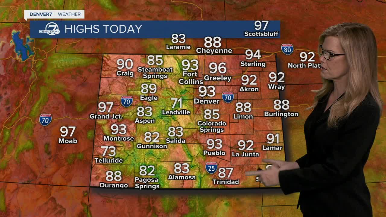
Your Heat Risk This Weekend
Denver is entering its first true heat wave of 2026 — and the timing couldn't be more challenging. Red Flag Warnings are already posted for western Colorado and the northeast corner of the state, where critically dry vegetation combined with gusty southwest winds creates dangerous wildfire conditions.
Saturday kicks it off with mid-90s from Denver through the eastern plains. A few isolated afternoon thunderstorms are possible — but don't count on them for cooling. These storms bring gusty winds and brief heavy rain rather than sustained relief, and small hail is possible.
The Heat Wave Day by Day
- Sat, June 7 — First 90°+ day of 2026 — mid-90s on I-25 Corridor
- Sat afternoon — Isolated thunderstorms possible — gusty winds, brief heavy rain, small hail
- Sat all day — 🔴 Red Flag Warning: Western CO & NE Colorado
- Sun, June 8 — Even hotter than Saturday — most areas stay dry
- Mon, June 9 — Brief relief — 80s return with increased storm chances
- Tue, June 10 — Hottest day of the stretch — mid to upper 90s, NE Plains near 100°
- Tue–Wed — Gusty SW winds, elevated to critical fire weather conditions
- Wed, June 11 — Still very hot, but gradual cooling begins as weather system moves in
- Thu–Fri, June 12–13 — Heat relief arrives — cooler and more comfortable
- Next weekend — Forecast trending cooler — fire danger still a concern through midweek
The brief Monday reprieve is real but short-lived. Highs drop back into the 80s with more moisture in the air — meaning afternoon thunderstorms become more likely. It won't feel cool by any stretch, but compared to weekend temperatures, the difference will be noticeable.
Then Tuesday turns the heat back up — hard. The combination of near-100° temperatures and gusty southwest winds creates what meteorologists call critical fire weather: low humidity, dry fuel, and wind to spread any ignition rapidly. Coloradans near open grasslands or wildland-urban interface areas should have evacuation plans ready.
Are You Ready for Denver's Heat Wave?
5 questions. Find out if your heat safety game is on point.
How much water should you drink per hour during outdoor activity in 95°+ heat?
- A full glass (8 oz) — That's not enough. At 95°+, you can lose 1–2 liters per hour through sweat. Aim for 24–32 oz per hour during activity.
- 24–32 oz (2–3 cups) — Exactly right. And don't wait until you're thirsty — by then, you're already mildly dehydrated.
- Whatever I feel like — Thirst is a lagging indicator. When temps hit 95°+, you need a schedule, not a feeling.
- Sports drinks count double — Sports drinks help replace electrolytes, but they don't replace water volume. Combine both.
You stop for 10 minutes with kids in the car, AC off. What's the interior temperature on a 95° day?
- About 95° — same as outside — Cars heat up much faster. Greenhouse effect from glass traps heat. Even cracked windows don't help enough.
- Around 115–125° — Correct. Car interiors can reach 120°+ in under 10 minutes on a hot day. A child's body temperature rises 3-5x faster than an adult's. Never leave children unattended.
- Around 105° — Close — but it's actually worse. 10 minutes in a sealed car on a 95° day can push interior temps above 115°.
- It depends on the car color — Color has minimal effect vs. the glass greenhouse effect. All cars heat dangerously fast.
What's the #1 warning sign that someone has crossed from heat exhaustion into heat stroke?
- Heavy sweating — Heavy sweating is actually a sign of heat exhaustion — your body is still trying to cool itself. Heat stroke is more dangerous.
- They stop sweating and skin is hot/dry — Right. When sweating stops and skin becomes hot and dry (or red), that's heat stroke — a medical emergency. Call 911 immediately and move them to shade or AC.
- Feeling very thirsty — Thirst is an early sign of dehydration, not heat stroke. Heat stroke symptoms are more severe: confusion, hot dry skin, rapid pulse.
- Muscle cramps — Cramps are a sign of heat cramps — the mildest form of heat illness. Heat stroke involves hot, dry skin, confusion, and loss of consciousness.
When is the most dangerous window for heat exposure in Denver this weekend?
- 10am – 2pm — Getting warmer — but Denver's hottest window is typically a bit later. Solar radiation peaks, but ground heat keeps building.
- Noon – 5pm — Correct. Noon to 5pm is the peak danger window. Ground surfaces absorb heat all morning and radiate it back — so 3–4pm is often hotter than solar noon.
- Sunrise – 10am — Mornings are actually the safest window for outdoor activity. Temperatures are at their daily low and humidity is slightly higher.
- It's equally dangerous all day — Heat risk does exist all day, but it's highly concentrated in the afternoon. Morning and evening are significantly safer.
A Red Flag Warning is in effect. What should people near open land or wildland areas do first?
- Water the lawn to create a buffer — Watering helps but isn't a first priority. Fire can spread faster than watering can keep up. Evacuation readiness comes first.
- Know your evacuation route and have a bag ready — Exactly right. Evacuation readiness is the #1 priority under Red Flag conditions. Know two routes out, have medications/documents ready, and register for local emergency alerts.
- Avoid grilling or using outdoor fire — True — no open flames under Red Flag conditions. But evacuation readiness is the more critical action if you live near open land.
- Check air quality apps frequently — Air quality monitoring is useful, but by the time smoke shows on an app, a fire may already be close. Know your route and be ready to leave fast.
Heat Wave by the Numbers: Denver vs. What's Coming
| Normal June High | This Weekend | Tuesday Peak | |
|---|---|---|---|
| Denver High Temp | 82°F | 95°F | 97°F |
| NE Plains High | 84°F | 95°F | 100°F |
| Fire Danger Level | Low–Moderate | High | Critical |
| Storm Chances | 20% | 30% Sat, <10% Sun | 10–20% |
| Wind (Afternoon) | 10–15 mph | 15–25 mph | 20–35 mph gusty |
| Safe Outdoor Window | 6am–7pm | Before 10am / After 7pm | Before 9am only |
Make sure to stay hydrated and take breaks from the sun during the hottest part of the afternoon.Denver7 Meteorologist Stacey Donaldson
Weekend vs. Next Weekend: A Tale of Two Forecasts
This Weekend (Hot)
- 95–97° Daily Highs I-25 Corridor
- 🔴 Red Flag Warning Active through midweek
- Near-zero storm relief Saturday
- Critical fire weather Tuesday
- Overnight lows stay warm
Next Weekend (Relief)
- Lower Daily Highs Gradual cooling trend
- ↓ Fire Danger Decreasing by Thu–Fri
- Better storm chances Monday
- Weather system brings relief
- More comfortable nights
Heat Wave Fast Facts
- 95 — Weekend High °F
- 100 — Possible Tuesday °F
- 10 — Min to Dangerous Car Temp
- 24 — Oz Water Per Hour Outdoors
- 5 — Days of Heat Risk
- 80s — Next Weekend Relief
Stay Safe This Weekend
- Hydrate Before You're Thirsty: Drink 24–32 oz of water per hour during outdoor activity. Start hydrating the night before a hot day.
- Time Your Outdoor Activity: Safe windows this weekend: before 10am or after 7pm. Peak danger is noon to 5pm.
- Red Flag Warning in Effect: Western Colorado and NE Colorado are under Red Flag Warning through the weekend. No outdoor burning. Know your evacuation route.
- Never Leave Kids or Pets in Cars: Interior temps reach 115–125° in under 10 minutes on a 95° day. Even with windows cracked.
- Find a Cooling Center Near You: Denver opens cooling centers when temps hit 90°+. Call 311 or visit the City of Denver website for locations.
- Sign Up for Emergency Alerts: Register for Wireless Emergency Alerts in your county — especially important during fire weather conditions midweek.
What Is a Red Flag Warning and Why Should You Care?
A Red Flag Warning is issued by the National Weather Service when a dangerous combination of conditions exists: low relative humidity (typically below 15%), sustained winds above 25 mph, and dry vegetation that can easily ignite and spread fire.
Under these conditions, a single spark — from a vehicle, a campfire, dragging chains, or even a lawnmower on dry grass — can start a fire that spreads faster than firefighters can respond. That's not a hypothetical. It has happened repeatedly on Colorado's eastern plains.
The warnings active this weekend cover western Colorado and the northeast corner of the state. By Tuesday and Wednesday, gusty southwest winds will push critical fire weather conditions into more of the state as the heat peaks. All outdoor burning is banned under Red Flag conditions. Fireworks — even legal ones — are prohibited in most of Colorado during fire weather.
If you live anywhere near open grassland, scrubland, or in a wildland-urban interface area (where homes meet undeveloped land), the next week is the time to have a go-bag packed, know two evacuation routes, and monitor Wireless Emergency Alerts.
Your Heat Wave Action Plan
- Test your AC now — Don't wait until Sunday afternoon. Run your AC today and make sure it's cooling properly — HVAC repair shops book up fast during heat waves.
- Stock up on water tonight — Have at least one gallon of water per person per day on hand. Add electrolyte packets for outdoor activity.
- Check on elderly neighbors Saturday morning — Adults 65+ are at the highest risk of heat-related illness. A knock on the door Saturday morning could save a life.
- Plan pet exercise before 9am — Pavement can burn paws — if it's too hot to hold your hand on asphalt for 7 seconds, it's too hot for your dog's paws.
- Know heat stroke symptoms — Hot, dry skin (not sweating), confusion, rapid pulse, unconsciousness. This is a 911 emergency. Move to shade and cool with water while waiting.
- Have your evacuation route ready by Monday — Tuesday and Wednesday bring the highest fire weather risk. Know two ways out of your neighborhood and register for county alerts.
Heat Wave Myths — What's Actually True?
Cracking car windows keeps the interior safe for pets and kids.
Verdict: false
Research shows cracked windows have virtually no effect on interior car temperatures. On a 95° day, a car interior reaches 115°+ in under 10 minutes regardless of window position.
Afternoon thunderstorms will cool things down this weekend.
Verdict: mostly false
Saturday sees isolated storm chances, but these are brief and spotty — most areas stay dry. The storms bring gusty winds and rain for minutes, not sustained cooling. Sunday is mostly dry and hotter.
You only need to worry about heat if you're physically active.
Verdict: false
Sedentary adults, especially those 65+ or with heart/respiratory conditions, are highly vulnerable even at rest. Indoor temperatures in homes without AC can exceed 90° by mid-afternoon.
The heat breaks completely next week.
Verdict: mostly false
There's a brief dip to the 80s Monday, then temperatures spike back to near-100° Tuesday and Wednesday before genuinely cooling Thursday and Friday. It's a roller coaster, not a single break.
Sports drinks are better than water during extreme heat.
Verdict: mixed
Both are needed. Water replaces volume lost to sweating; electrolyte drinks replace sodium and potassium. Drinking only water during extended heat exposure can cause hyponatremia (low sodium). Use both.
Sources & References
- Primary source: local-news — Stacey Donaldson
- National Weather Service — Denver/Boulder — Temperature forecasts, Red Flag Warning criteria, and fire weather outlooks for Colorado
- CDC — Heat Stress / NIOSH — Hydration guidelines (fluid intake per hour during heat exposure), heat illness symptom thresholds, and prevention recommendations
- NHTSA — Heatstroke Prevention — Vehicle interior temperature data (how fast cars heat up on hot days) and child heatstroke statistics
- Colorado Division of Fire Prevention and Control — Red Flag Warning definitions, fire restriction levels, and wildland-urban interface evacuation guidance
- City and County of Denver — Office of Emergency Management — Cooling center activation thresholds and 311 resource referral for heat emergencies