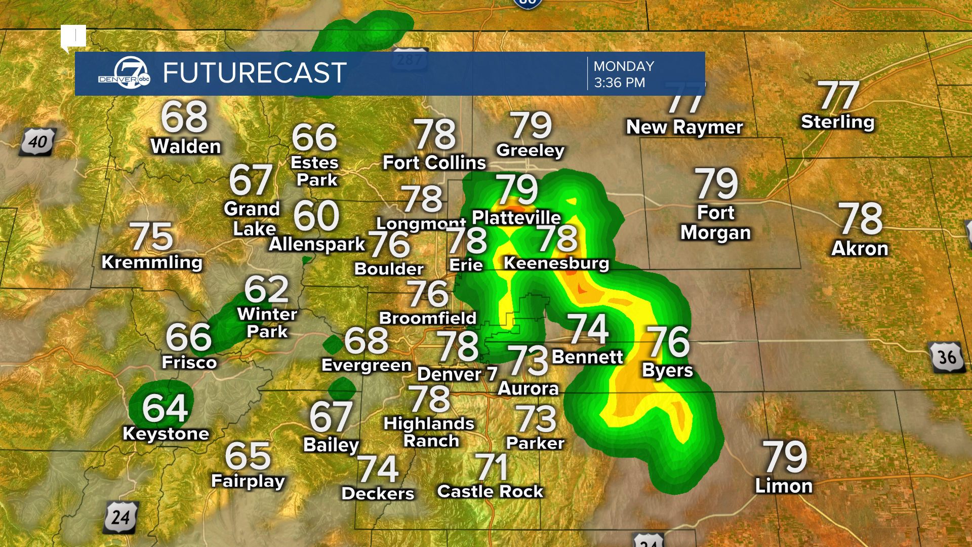
Your Storm Risk Today
Monday's storms are expected to fire up close to the Denver metro around 2 p.m. before tracking northeast toward the plains — a classic Colorado afternoon thunderstorm setup. The primary threats are large hail and damaging winds, but isolated tornadoes remain possible, particularly during the early window when storms are still organizing.
If you have outdoor plans this afternoon — a game, a run, a patio happy hour — keep a close eye on the radar from noon onward. When you hear thunder, head inside. Colorado storms can go from zero to severe in under 30 minutes.
This Week's Storm Timeline
- Monday 2PM+ — Storms develop near Denver metro — hail, damaging winds, isolated tornadoes possible
- Monday Evening — Storms track northeast to the plains — severe threat continues
- Tuesday Afternoon — Another round of afternoon thunderstorms — hail and strong winds possible
- Wednesday — Severe weather threat lowers — thunderstorms still in the forecast
- Thursday–Friday — Continued afternoon storm chances — temps climbing toward 80°
- Weekend — Afternoon highs approaching 90° — drier and warmer pattern likely
- Next Weekend — Forecast models suggest warmer, drier pattern returns to Colorado
Isolated tornadoes cannot be ruled out — especially during the early stages of storm development this afternoon.Denver7 Forecaster Clara Faith
Are You Storm-Ready?
5 quick questions to check your severe weather prep before 2 PM.
Do you have Wireless Emergency Alerts turned ON on your phone?
- Yes, always on — Good. WEAs push automatically — no app needed. You'll get tornado warnings directly from the NWS.
- Not sure — Go to Settings → Notifications → Emergency Alerts and make sure they're enabled. Takes 30 seconds.
- No, I've turned them off — Turn them back on today. Tornado warnings require fast action — you need that alert even if you're sleeping or driving.
Do you know where your safe room or lowest-floor interior room is?
- Yes, I know exactly where to go — Basement or lowest interior room away from windows is ideal. Make sure everyone in your household knows the plan.
- Kind of — I'd figure it out — Walk through your home today and identify the spot. Interior bathroom, closet, or hallway on the lowest floor are all solid options.
- I live in a mobile home / no basement — Mobile homes are NOT safe during tornadoes. Identify the nearest sturdy building you can reach in under 60 seconds.
Can you access a live radar right now?
- Yes — app or Denver7.com — Keep it handy from noon onward today. Storms can develop and intensify quickly on Colorado's plains.
- I rely on TV or radio — That works — Denver7 will interrupt programming for severe weather. But a phone radar lets you track storms in real time.
- No — I just check the weather app — Standard weather apps lag behind live radar by 10-20 minutes. Download a radar app like RadarScope or use Denver7.com for real-time data.
Is your vehicle parked somewhere protected from hail?
- In a garage — I'm covered — Perfect. Golf-ball-size hail can total a vehicle. If you have a garage, use it by noon today.
- Outside, but I can move it — Plan to move it to a garage or covered structure before 1 PM. Hail damage claims skyrocket on storm days in Colorado.
- Street parking only — no options — Consider a hail blanket if you own one. Otherwise, document your car's condition with photos now so any claims are easier to file.
Do you have outdoor plans between 2 PM and 7 PM today?
- No outdoor plans today — You're in good shape. Just keep an eye on alerts in case anything changes for the rest of the week.
- Yes, but I can reschedule/shelter quickly — Know the 30-30 rule: if you see lightning and hear thunder within 30 seconds, head inside and wait 30 minutes after the last thunder.
- Yes — major outdoor event, can't cancel — Know your venue's lightning plan. Most stadiums and parks have designated shelter areas. Identify them before the event starts.
Threat Breakdown: Denver Metro vs. Eastern Plains
| Denver Metro | NE Colorado Plains | Foothills / Boulder | |
|---|---|---|---|
| SPC Risk Level | Slight (2/5) | Slight–Enhanced (2-3/5) | Marginal (1/5) |
| Large Hail | Likely | Likely | Possible |
| Damaging Winds | Possible | Likely | Unlikely |
| Isolated Tornado | Possible | More Likely | Unlikely |
| Storm Start Time | After 2 PM | 3 PM – 8 PM | Isolated PM |
| Weekend Outlook | Near 90°, Drying | Near 90°, Drying | Near 80°, Dry |
Here's the week in a nutshell: storm chances are daily through at least Thursday, with each round firing up in the afternoon heat and tracking east and northeast. The good news is temperatures are pleasant — highs near 80° through mid-week. The weekend brings the warmest stretch, potentially touching 90° Saturday afternoon, with drier conditions likely returning by next weekend.
Wednesday offers a slight reprieve from severe weather concerns, though t-storm chances remain in the forecast. Think of it as a lower-intensity day in an otherwise active week. Keep plans flexible and keep alerts on every day — these storms don't always follow the script.
Daily Severe Weather Threat This Week (1–5 scale)
This Week vs. Next Weekend
This Week (Mon–Fri)
- Daily Storm Chances Afternoon rounds every day
- 80° Peak Temps Mid-week highs
- Large hail threat most days
- Tornado cannot be ruled out Mon–Tue
Next Weekend
- Drying Out Storm Chances Drier pattern returning
- 90° Peak Temps Warming through weekend
- Mostly sunny afternoons likely
- Lower severe weather risk
What To Do Before 2 PM Today
- Enable Emergency Alerts: Settings → Notifications → Emergency Alerts. Takes 30 seconds and could save your life.
- Bookmark the Live Radar: Track storm cells in real time on Denver7.com — updated every few minutes during active weather.
- Protect Your Vehicle: Move your car to a garage or covered structure before 1 PM. Golf-ball hail can total a vehicle.
- Know Your Safe Room: Lowest floor, interior room away from windows. In a mobile home? Identify the nearest solid structure now.
- Watch the Full Forecast: Denver7's Clara Faith has the complete storm breakdown with radar timing and 7-day outlook.
Storm Myths vs. Reality
If the sky is blue in the morning, you're safe from afternoon storms.
Verdict: false
Colorado's terrain and strong daytime heating routinely produce severe storms that develop from clear skies in a matter of hours. Morning sunshine means nothing for afternoon storm potential.
Tornadoes can't happen in Denver — the mountains block them.
Verdict: false
The Denver metro and eastern plains see tornado activity regularly. The mountains to the west do not prevent storm development along the Front Range and Palmer Divide.
You're safe from lightning in your car.
Verdict: mostly true
A hard-topped metal vehicle offers good protection — but NOT a convertible or fiberglass vehicle. Keep windows up and avoid touching metal surfaces inside.
Hail warning = tornado warning.
Verdict: false
Large hail is a product of severe thunderstorms but does not automatically mean a tornado is occurring. However, the same storms that produce hail can also produce tornadoes — treat all severe warnings seriously.
What Is a 'Slight Risk' From the Storm Prediction Center?
The Storm Prediction Center in Norman, Oklahoma issues daily severe weather outlooks for the entire United States. Their 5-level scale runs from Marginal (1) through Extreme (5). A Slight Risk — Level 2 — means organized severe weather is expected. It's not the worst-case scenario, but it's a real and significant threat that forecasters take seriously.
For Denver and the Front Range, a Slight Risk typically means you can expect at least a few strong-to-severe storms, with hail and wind as the primary threats. The tornado risk at this level is real but lower probability — 'isolated tornadoes cannot be ruled out' is forecaster language for a 5-10% tornado probability.
At Level 3 (Enhanced) or above, things get significantly more dangerous. Denver seeing back-to-back days under any SPC risk in the spring and early summer is completely normal — eastern Colorado is one of the most active severe weather corridors in the country.
Sources & References
- Primary source: local-news — Clara Faith
- NOAA Storm Prediction Center — Daily severe weather outlooks and risk level definitions (Marginal through Extreme)
- National Weather Service — Boulder, CO — Severe thunderstorm and tornado warning criteria for the Denver metro and Front Range
- FEMA / Ready.gov — Severe thunderstorm and tornado preparedness guidance — safe rooms, emergency alerts, mobile home safety
- Denver7 Weather Team — Local storm timing, 7-day forecast, and FutureCast radar projections for Denver and eastern Colorado